
Last week, while researching the 1913 postcard showing the Philip Schumm home, I noticed that according to the 1910 census, the Philip Schumm family lived on Schumm Pike in Black Creek Township, Mercer County, Ohio.
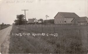
Philip Schumm farm, Rockford, Ohio, 1913 picture postcard.
Schumm Pike. Interesting. And how appropriate! A Schumm living on Schumm Pike.
Plus, it is another clue to where the 1913 postcard house was located.
Just where was Schumm Pike? Fred and J.F. Schumm owned a fair amount of property just west of Rockford, in the Labadie and Charley Reserves. What is now U.S. Route 33 ran through their property. It appears that Schumm Pike was that section of the current Route 33 going west out of Rockford, between routes 33/118/Main Street and the Van Wert County Line. Maybe even going into Van Wert County.
Several years ago, at the Shanes Crossing Historical Society, Mike Schumm mentioned that a Rockford-area road was once called Schumm Pike, and I had forgotten about that until I saw the name Schumm Pike on the 1910 census page last week.
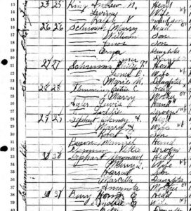
Schumm Pike, Philip Schumm, 1910 U.S. Census, Black Creek Twp, Mercer County, Ohio.
The first column on the 1910 census is for the name of the street the family/person lived on. Black Creek Township’s census taker went the extra mile and listed the roads people lived on. Unfortunately, Dublin Township’s 1910 census taker did not list the township’s roads. Therefore, Schumm Pike is not listed in Dublin Township in 1910 and we don’t know who lived along the Schumm Pike there. However, in 1910 the Rockford street names are listed and near the end of the town’s enumeration is Fort Wayne Road. That was very likely what is now Route 33, aka Schumm Pike back then.
Did Schumm Pike stop at the Mercer-Van Wert County line? We don’t know because in 1910 the rural road names are not listed in Willshire Township either.
Let’s look at the 1910 census, where there were 17 households along Schumm Pike in Black Creek Township, between the Dublin-Black Creek Township Line and the Mercer-Van Wert County line:
Mary Schumm (widow of Fred Schumm Jr), 49
Philip Schumm, 27
Estus C. Flemming, 25
Lewis Agler, 22
Chancy Gephart, 36
Maynard Gephart, 33
Homer E. Bury, 23
Robert Watson, 62
Marcus Tice, 42
Ferdinand Dreyer, 57
Zachariah H. Hartzog, 59
William W. Hufford, 35
Joseph Mottinger, 50
Henry C. Buechner, 42
Albert Jefferies, 54
Thomas J. Friedly, 41
Elijah H. Alspaugh, 32
Two other sources, the 1900 Black Creek plat map and the 1910 Black Creek Decennial Appraisement maps show there were about 14 houses along what is now Route 33 between Township Line and the County Line.
Another interesting document from the Shanes Crossing Historical Society, an undated land survey by A.J. Dellinger of 37 acres of land located on the north end of Rockford. Schumm Road is labeled on the map and is used as a reference point for the survey:
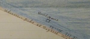
Schumm Pike, undated survey by AJ Dellinger
It reads: Said tract of land out of North East Corner of Lands now owned by J.F. Schumm in Charles Reservation Town four (4) South of Range one (1) East Lot four (4) in Mercer County Ohio…to center of said Schumm Pike thence along center of said Schumm Pike about 60 degrees…to south bank of St. Marys River thence south…
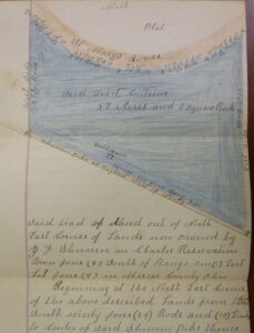
Schumm Pike, undated survey by AJ Dellinger
Schumm Pike was also mentioned a couple times in The Celina Democrat:
Claims Allowed…C.J. Schumm, Supt. Schumm Pike, $14.81… [1]
PIKE DIRECTORS
COMMISSIONERS
A petition was filed with the board last Friday by J.F. Karns, et al, praying for the improvement of a pike along the following route: Beginning at the junction of the Addy pikes 1 and 2; thence north along the township line between Dublin and Black Creek townships, until it intersects the Schumm pike, a distance of about a mile and a quarter…
Addy Pike(s), another road name from the past. I wonder if one section of Addy Pike was what is now Rockford West Road. Perhaps someone has heard of Addy Pike and knows where it was.
It is interesting to look at the 1910 census of Black Creek Township and see the local roads that were named after a family who probably lived on that road. Road names include Eichler Pike, Leininger Pike, Baker Pike, Brandt Pike, Winkler Road, Addy Pike, Schumm Pike, Dudgeon Road, Cross Road, Hoblet Road, Evans Road, Dellinger Road, Rutledge Pike, Robinson Road, Huffmann Road, Harb Pike, Bartlet Road, and Stover Road. Brandt Pike seemed to be quite long and I suspect it ran from the Van Wert-Mercer County Line to Chatt. Some of those road names are still used today, such as Winkler Road.
Many of the family-related road names were changed over the years. Roads such as Schumm Pike and Brandt Pike were renamed as State or U.S. highways. No road names were listed in the 1920 census but in 1930, what is now U.S. Route 33 west of Rockford was named State Road 54, at least in Black Creek Township and maybe even a longer section of the road. By 1940 the road was renamed as U.S. 33. Column one of the 1940 census specifically lists the road as Route U.S. 33, Formerly Route U.S. 54.
Sometime between 1915 and 1930 that section of highway was no longer called Schumm Pike.
[1] The Celina Democrat, Celina, Ohio, 24 Jun 1910; Newspaperarchive.com, viewed 4 Sep 2023.
[2] The Celina Democrat, Celina, Ohio, 4 Feb 1915; Newspaperarchive.com, viewed 4 Sep 2023.
4 comments
Skip to comment form
Thomas J. Friedly was my great-grandfather. His wife, Malinda and son, Floyd also lived with him in the home on Schumm Pike. I do remember seeing that address for the family when I was doing research as well. Their property was just west of Erastus Durbin Road on the south side of the road. The barn still stands but the house burned down several years ago. A manufactured home was put in its place. My aunt and uncle, Geraldine and Don Shaffer lived on the farm for many years after purchasing it from the estate of Malinda Friedly.
Thanks for sharing!
Deb Reichard
Author
That is so interesting and another connection to the road name. I know where you are referring to and it looks like the land was in the Friedly family for quite some time, looking at the old plat maps. Thank you for the additional information.
Karen,
I am not as familiar with Ohio roads and how they were created and named but I do know that it was common practice in Indiana that a road was often named after a petitioner for the creation of the road. This typically was a family that lived along or beside what would become a road and gave them access to the surrounding area, village/town or even grain elevators and dealers. Note that while there may have been other families or farms along the proposed new road, typically the folks would get together discuss and decide if they needed a new roadway and appoint a representative to petition the township, county or other governmental authority for the new road. Thus the road potentially would be named after the person representing all of the neighbors involved. Certainly not true in every case but it can be a clue to investigate if a road was named after one of your ancestral families.
Author
That makes so much sense. I did not know how that process worked and Indiana and Ohio likely were very similar in that process. Thank you for writing and explaining that. It is certainly interesting to see all the old road names, which helps you figure out where families may have lived.