
A couple weeks ago I featured a 1913 photo postcard of the Philip Schumm farm but I had still questioned where the house and barn were located and the name that was written on the barn.
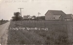
Philip Schumm farm, Rockford, Ohio, 1913 picture postcard.
I now believe this was where Velma Schumm lived on U.S. Route 33 west of Rockford. This was probably the house she was born in 1914 and back then that stretch of road was known to the locals as Schumm Pike.
The frame house pictured on the postcard was probably torn town and replaced with the current craftsman-style brick home around 1920. According to the Mercer County Auditor website the brick house was built about 1920. Also, according to that same website, the barn east of the house was built about 1900. That means the barn pictured in the postcard is still standing.
The barn looks rather new on the postcard and according to the auditor information, it would have been about 12 years old at that time. All this seems to fit the timeline.
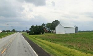
What was once Philip Schumm property, Google Earth photo, June 2023
This Google Earth photo shows the barn as it looks today. It has been resided but it is the same shape and size and is in the same location. The house and barn are about the same distance from the road as those pictured on the postcard.
As for the names on the barn, Maplewood Farms is clearly visible on the barn but the name above it is much harder to make out. The last name just doesn’t quite look like Schumm.
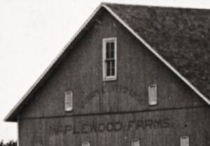
Barn on Philip Schumm farm, 1913, “Maplewood Farms”
I believe the name on the barn is Lorin C. Springer. According to the 1900 Black Creek plat map, Lorin C. Springer owned about 211 acres in the Labadie Reserve, the same section where I believe the Philip Schumm home photo was taken in 1913. Where U.S. Route 33 runs through.
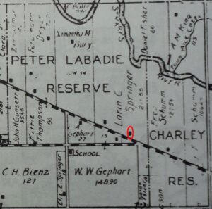
Location of where Philip Schumm farm would be, 1900, Black Creek Township.
Black Creek’s 1910 Decennial Appraisement shows that Lorin C. Springer owned 111 acres in the same section. He owned the land but apparently he did not live on the property in 1900 or 1910. He and his wife Alice Luella (Bower) lived in Rockford.
Lorin C. Springer was born in Mercer County, Ohio, 15 Oct 1859, the son of William Springer (1829-1883). Lorin Springer and Alice Bower married in Mercer County in 1886. [1] In 1900 Lorin, 42, married (for 13 years), lived on East Second Street, Rockford, and was a boarder in the Emanuel Brown household. [2] His wife Alice Luella was living with her parents, in the Emanuel W. Bowers household on West Market Street, Rockford. [3]
In 1910 Lorin and his wife lived on South Street in Rockford. The couple did not have any children. [4]
There are a couple possibilities here. Perhaps Lorin C. Springer sold his property to Philip Schumm between 1900 and 1913 or Philip Schumm may have rented the home from Springer. I have not been to the recorder’s office to check the deeds, which would likely answer this question.
From Sutton’s 1882 History of Van Wert and Mercer Counties, Ohio, concerning Lorin’s father William Springer: Mr. [William] Springer was rather of a discontented mind or disposition; was never content to remain long in one place. He has twice been to California and moved from place to place a number of times, until in 1869 he bought his present home in Black Creek Township, where he proposes to remain the balance of his days.
William Springer did just that. He died there in Black Creek Township in 1883 and is buried in Riverside Cemetery, Rockford, Ohio.
The lure of California must have run in the family because by 1920 Lorin C. Springer and his wife had moved to California, where he lived for the rest of his life. [5]
[1] Ohio, U.S., County Marriage Records, 1774-1993, Mercer County, Vol 1861-1887, p.394, Lorain [sic] C. Springer and A.L. Bower, 16 Sep 1886; database online, Ancestry.com.
[2] 1900 U.S. Census, Dublin, Mercer, Ohio, ED 78, p.13, dwelling 277, family 184, Emanuel Brown; Ancestry.com.
[3] 1900 U.S. Census, Dublin, Mercer, Ohio, ED 78, p.8, dwelling 172, household 179, Emanuel W. Bowers; Ancestry.com.
[4] 1910 U.S. Census, Dublin, Mercer, Ohio, ED 111, p.6a, dwelling 172, household 179, Lorin C Springer; Ancestry.com.
[5] 1920 U.S. Census, Long Beach, Los Angeles, California, ED 84, p.10B, dwelling 194, family 210, Lorin C Springer; Ancestry.com.

6 comments
Skip to comment form
9-15 Blog. My opinion is that they are not the same barn. The barn in the Google Earth photo shows a barn that is the same length as the height. The barn in the Schumm picture measures longer than it is high. It appears to be about 6-8 feet longer than the Google Earth photo. Location of the barn on the land and distance from the road match but I don’t believe the length of the barns are the same. Good information on the Springers.
Author
Good observations and you may be correct. It does look that way. It is really hard to tell without measuring it since the barn has been resided. Thanks for writing!
My name is Larry Schumm, my 2 brothers & I lived in my grandfather’s farm: L William Schumm. this farm is across US33 on corner of Winkler Rd. Leona was a sister to my grandfather and Frederck was there father. Note the land owned east of Philip & Leona reads Fred Schumm. My great uncle Amos lived on that farm when I lived on grandfathers farm. We lived there between 1950 (?) till Feb. 1962. Thanks for the posts, I really enjoy them. Larry
Author
Thanks for writing, Larry. You certainly would know the area, having lived there and with your Schumm relationships. Yes, the Schumms owned quite a bit of land along 33 at one time and good to confirm where Amos, Philip, and L William lived. Concerning the (Philip Schumm) barn in question, do you remember what it looked like before it was sided? Do you think it is the same barn as in the old 1913 photo? Thanks for writing!
Hi Karen, I was so interested in your map. CH Bienz was my great grandfather. I never knew him, but I do have memories of his wife, Hyla. I remember going past their house but the memory of the location has faded. Perhaps because the house was remodeled or torn down. Is the road sr 49? Thanks for all your interesting posts.
Author
Aren’t these old maps great! The road going diagonally, angling upward toward the left, is U.S. 33. The road that meets 33, near the red circle, is Winkler Road. The right side of the map is the Township Line. This portion of map is in Black Creek Township and Dublin Township would be to the right, but you don’t see Dublin Twp. Looking at the whole 1900 map, looking at the CH Bienz property, he owned 127 acres and it appears that his house was to the southwest, on Jordan Road. That is where the house for that property was located. Does Jordan Road ring a bell? CH Bienz actually died in 1900, survived by wife Mary. Their son Abraham Walter Bienz (1873-1919) had a wife Hyla and in 1910 they lived in Willshire Township. Perhaps this is the couple you are thinking of? There were quite a few Bienzes in the area at that time. Did you see the blog post with the Bienz photo? Titled A Bienz-Ross Photo Mystery. You might find it interesting if you haven’t already read it. Thanks for writing!