George Geisler was lucky to survive being shot twice, and he even lived a few more years after the incident.
The following are newspaper accounts of the December 1938 shooting of the Willshire Township native.
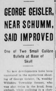
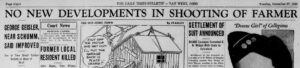
GEORGE GEISLER, NEAR SCHUMM, SAID IMPROVED
One of Two Small Caliber Bullets at Base of Skull
No new developments have been uncovered in the mysterious shooting of George Geisler, 73, wealthy Willshire Township farmer, who was shot twice in the head, from ambush, while reclining in a chair in the summer kitchen at his farm west of Schumm.
Geisler, who was shot last Thursday at about 7:30 p.m. and not found until Saturday noon, was reported in an improved condition today in Adams County Memorial Hospital at Decatur, Indiana, by the attending physician, Dr. L. M. Githens of Wren.
Dr. Githens reported that both bullets, apparently fired from a small caliber weapon, had been located, however no effort would be made to remove them at present. One of the bullets was located at the base of the skull. The other shattered as it entered his head. Neither missile caused locomotive paralysis, and at no time did the wounded man become unconscious. Geisler has been given a good chance to recover.
Geisler was found about noon Saturday by Laurel Bowen, a neighbor, who made an investigation after Elton Vining, rural letter carrier, reported that Geisler’s mail had not been removed for two days. Geisler was found on the floor of the summer kitchen and had been without food or water since Thursday night. He was weakened considerably by loss of blood.
Geisler was questioned at the hospital by Sheriff R. B. Stevens. Geisler stated that while sitting in the summer kitchen, he felt a sting just below the right ear that caused him to reel from the chair onto the floor. Shortly afterwards, he said he managed to crawl back to the chair when he was struck on the opposite side of the head. He said that at no time did he hear or see anyone.
Tracks in the snow, just outside the summer kitchen window, indicate that Geisler’s unknown assailant stood there some time before shooting. The bullets passed through a screen and window at different angles, Stevens said.
Stevens said that while there were no indications of robbery, he expressed the belief that the assailant visited the Geisler farm with that intent, and that after shooting the elderly man, he apparently “got cold feet.”
Geisler linked his assailant with a masked bandit who endeavored to rob him several months ago as he walked through the woods to his mailbox. Geisler said that the masked man, flashing a revolver, searched him for money and then ordered him to return home. He described the masked man as tall and slender. [1]
The Daily Times-Bulletin, 27 Dec 1938
In another news article the following day, the physician reported that George appeared stronger and was able to move his head without pain.
However, it took some time for George Geisler to recover and return home:
MAN SHOT SIX MONTHS AGO TAKEN HOME FROM HOSPITAL AT DECATUR
George Geisler, 69-year-old Willshire Township recluse, who has been a patient at Adams County Memorial Hospital in Decatur for the past six months suffering from two bullet wounds at the base of the brain, has been removed to his home near Willshire.
Geisler, while sitting in a chair in the summer kitchen at his home, was twice shot by an unknown assailant who fired through a window. The shooting occurred the night of December 22, and his plight was not discovered until two days later…
Geisler was shot through both the left and right sides of his head, the bullets producing partial paralysis. No effort was made to remove the bullets, which were said to have been fired from a .22 caliber weapon. Authorities have been unable to secure any clues as to the identity of his assailant. [2]
Van Wert Times Bulletin, 21 June 1939
It is amazing that George lived another 5 years after being shot in the head twice. His obituary:
GEORGE GEISLER STRICKEN AT 79
Willshire Township Resident Died in Hospital
George Geisler, 79, bachelor of Willshire Township, died at 7:30 a.m. today at Van Wert County Hospital where he had been a patient a week. He had been ill for three weeks.
The deceased was a native and lifetime resident of Willshire Township. A brother and sister preceded him in death. His only survivors are two cousins, Mrs. T.B. DeWitt of North Walnut Street and Mrs. Lena Schumm of Willshire Township.
The funeral will be Friday at Zion Lutheran Church, Schumm, Rev. Alfred Moeller, officiating, interment in the church cemetery. [3]
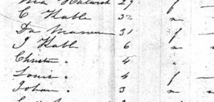
I wrote a Tombstone Tuesday about George Geisler a few years ago, Tombstone Tuesday-George Geisler. George was born in Willshire Township on 6 June 1864, the son of Johann “Nicholas” and Elisabeth (Stemling) Geisler. His parents were both German immigrants. He was a farmer and lived all his life on the family farm a couple miles east of Willshire. He never married.
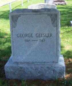
George Geisler, Zion Lutheran Cemetery, Van Wert County, Ohio. (2012 photo by Karen)
George Geisler died at the Van Wert County Hospital on 3 November 1943, his death caused by heart problems. There was no mention about the two bullets in his skull on his death certificate.
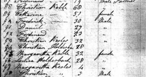
Of course there is a Schumm connection here. Not only was George a member of Zion Lutheran Church at Schumm, but, as mentioned in his obituary, his cousin was Magdalena “Lena” (Geisler) Schumm (1868-1946), the second wife of River Henry Schumm (1844-1922). George’s father Nicholas Geisler and Lena’s father George Geisler were brothers.
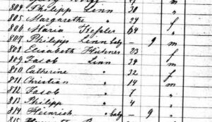
Also interesting is that one article mentioned that George was found by Laurel Bowen (1909-2003). Laurel’s wife Edith (Dudgeon) (1911-1997) was my 5th grade teacher at Parkway, in Willshire.
Plus, Edith was a sister to Robert Dudgeon (1903-1992), who married Bernice Brewster (1907-1994). Bernice was a sister of my paternal grandmother Gertrude (Brewster) Miller (1896-1973).
Small world.
And what an amazing story.
[1] George Geisler, Near Schumm, Said Improved, The Daily Times-Bulletin, Van Wert, Ohio, Tuesday, 27 Dec 1938; Newspaperarchive.com.
[2] Man Shot Six Months Ago Taken Home from Hospital at Decatur, Van Wert Times Bulletin, Van Wert, Ohio, 21 Jun 1939; Newspaperarchive.com.
[3] George Geisler Stricken at 79, Van Wert Times Bulletin, Van Wert, Ohio, 3 Nov 1943; Newspaperarchive.com.
You can contact Karen at karen@karenmillerbennett.com