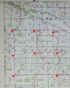
Below are two more Mercer County townships, Hopewell and Union, from the 1913 Topographic Map of northern Mercer County. I featured Black Creek, Liberty, and Dublin Townships from this map a couple weeks ago.
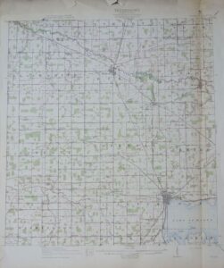
1913 Topography Map Northern Mercer County, Ohio
Apparently I have just a portion of a map. The sheet I have includes northern Mercer County, with the eastern portion of the eastern townships missing. The entire map is probably out there somewhere, just not in my possession.
I noticed a couple other items of interest while looking over the map. Most roads are not labeled, but a couple roads that are labeled have different names today.
Back in 1913 Tama Road was called Liberty Road and SR 29 going west out of Celina was called State Line Road.
I marked the township schools below, but the railroads are also included on the map, if you enjoy seeing where the railroads were.
Since there are not many road names on the map, I added what would be the current location for each school below each map.
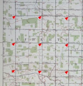
In Hopewell Township are the following schools, spelled as they are on the map: Stedke School, Siebert School, Copp School, Clutter School, Ham School, Pearstof School, Joint School No. 10, Joint School No. 1, Miller School, Five Points School.
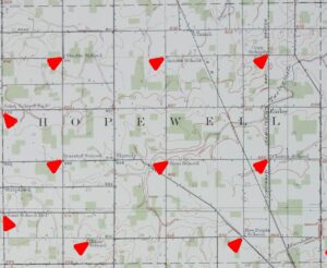
Hopewell Twp, 1913 Topography Map, Mercer County, Ohio
Where Hopewell Township Schools would be located on a current map:
Stedke School: Now & Hawk
Siebert School: Fast & Hellwarth
Copp School: Fast Road, a little west of US 127
Clutter School: Weitz & Morrow
Ham School: Hellwarth & Morrow
Pearstof [Pierstorff]: Frahm Pike & Now
Joint School No. 10: Township Line & Oregon
Joint School No. 1: Township Line & Hone-Wier
Miller School: Miller Road, west of SR 118
Five Points School: Frahm Pike & Miller & Hoenie
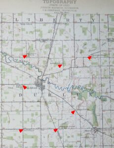
In Union Township are the following schools, spelled as they are on the map and noting the eastern portion of the township is not included on the map: Blue Corner School, Gross School, Victor School, Protzman School, Fryer School, School No. 2, School No. 1, Red School.
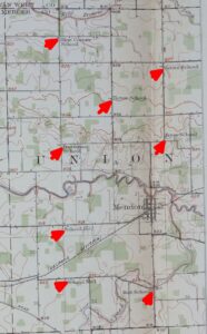
Union Twp, 1913 Topography Map, Mercer County, Ohio
Where Union Township Schools would be located on a current map:
Blue Corner School: Ross & Tomlinson
Gross School: SR 707 & SR 117
Victor School: Dutton Rd, between SR 117 & Shelley
Protzman [Protsman] School: Tomlinson & Hamilton
Fryer School: SR 707 & Hamilton
School No. 2: SR 707, west of Taylor Rd
School No. 1: Mercer Rd, between Palmer & Siler
Red School: Mercer Rd. & Celina-Mendon Rd
I hope you enjoy looking at this map and seeing where the old schoolhouses were.
You can contact Karen at karen@karenmillerbennett.com