Category: Mercer County Ohio

Pleasant Hill Chapel, Dublin Township

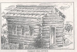
Pleasant Hill. Pleasant Grove. Pleasant Valley. Pleasant Chapel. Mount Pleasant. Pleasant Green. Pleasant Mills. Pleasant was certainly a popular, and pleasant, name. Especially for a church. When East Bethel church was organized in Black Creek Township in 1855, they planned to name it Pleasant Bethel but decided not to because there were seven other churches …

Continue reading

1913 Topography Map: Hopewell & Union Townships

Below are two more Mercer County townships, Hopewell and Union, from the 1913 Topographic Map of northern Mercer County. I featured Black Creek, Liberty, and Dublin Townships from this map a couple weeks ago. Apparently I have just a portion of a map. The sheet I have includes northern Mercer County, with the eastern portion …

Continue reading

1913 Topography Map of Northern Mercer County

I hope everyone had a nice holiday season. We certainly did and things are pretty much back to normal here. This winter seems more like the winters we used to have, colder with more snow, making it the perfect time to work indoors on some genealogy projects. As I mentioned late last year, I still …

Continue reading

Stringtown School, 1921

Thanks to Denny for sending this 1921 photo of the students of Stringtown School. Stringtown School No.8 was located in Dublin Township, Mercer County, Ohio, a couple miles south of Rockford…

Historic County Boundary Maps

If you enjoy seeing how county boundaries changed over the years, you will want to take a look at The Newberry Library’s online Atlas of Historical County Boundaries…