")
Visiting another historic mural in the area, this week going to St. Marys, in neighboring Auglaize County. Auglaize County was established in 1848 and was originally part of Mercer County. Prior to 1839, St. Marys was the county seat of Mercer County.
The St. Marys’ mural is a triptych, divided into three panels. It is located in Heritage Park, on the corner of East Spring and North Chestnut Streets. The murals were painted by the late Dan Keyes of New Bremen and were completed in 2006.

St. Marys, Ohio, historic mural, Heritage Park
The three murals are titled “Traces of St. Marys” and tell the history of St. Marys from the Native American settlement through the 20th century.

Girty’s Town, St. Marys, mural, Heritage Park. (2025 photo by Karen)
The GIRTY’S TOWN panel, the left mural, represents the Native American and European settlement in the area. The St. Marys River, named by the French, was the principle means of travel by the Native Americans and the French. Revolutionary War veterans also settled in the area, then known as “Girty’s Town” and named after James Girty’s trading post. Girty was considered a renegade because of his alliance with the British and Native Americans during the Revolutionary War and the Northwest Indian Wars. Girty is shown retrieving goods in the presence of General Wayne’s army. Fort St. Marys was built in 1794 to supply Wayne’s army and Fort Barbee was built there during the War of 1812 by Col. Joshua Barbee. The Treaty of 1817 was one of seven treaties signed in St. Marys.

Canal Town, St. Marys, mural, Heritage Park. (2025 photo by Karen)
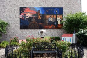
The CANAL TOWN panel, the center mural, shows Charlie Murray and other pioneer settlers, as well as a Circuit Rider establishing the first churches. A man tends to a lock on the Miami & Erie Canal. Locks 12N and 13N are in St. Marys. Lock 13N has been restored and is visible along the canal between Spring and High Streets, north of Memorial Park. The mill industry flourished because of the canal and the canal boat captain is paying “cash-on-the-barrelhead” to a farmer. His goods include a blanket, symbolizing the blankets made for decades at the St. Marys Woolen Mill. The canal boat travels backward while the railroad is going forward.

Boom Town, St. Marys, mural, Heritage Park. (2025 photo by Karen)
The BOOM TOWN panel, the right mural, represents the years from 1880 to the 1920s. A couple ride in a carriage made locally. The distant oil derricks show the area oil boom. Grand Lake St. Marys was the site of the first off-shore oil well in 1891. A worker paints camouflage artillery wheels produced at the St. Marys Wheel & Spoke Company. Another worker pours molten metal at the St. Marys Machine/Foundry. A man reads the Evening Leader newspaper while sitting on an automobile seat with a tire and rim at his side, representing modern manufacturers and St. Marys’ tire factory. Figures in the interurban represent historic individuals from St. Marys, Brigadier General August Willich, Jim Tully, Galen Cisco, Charles Makley, and Neil Armstrong. The Ferris wheel was once in Gordon State Park and the nurse points toward the future and the hospital that opened in 1953.
These murals relay a lot of information and show the history of St. Marys very well.
In addition to the murals, displays on the park’s ground show the city’s international relationship with Lienen, Germany, and Awaji City, Japan.

Display showing relationship with sister cities in Germany and Japan. (2025 photo by Karen)
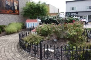
Display showing relationship with sister cities in Germany and Japan. (2025 photo by Karen)
St. Mary’s Heritage Park is a beautiful area with benches, a fountain, and a little pond.
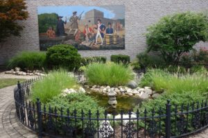
Small pond in front of Girty’s Town panel. (2025 photo by Karen)

Fountain in front of Canal Town panel. (2025 photo by Karen)
International area in front of Boom Town panel. (2025 photo by Karen)
You can read more about St. Marys’ Heritage Park and the town’s murals here:
https://www.cityofstmarys.net/facilities/facility/details/heritage-park-3