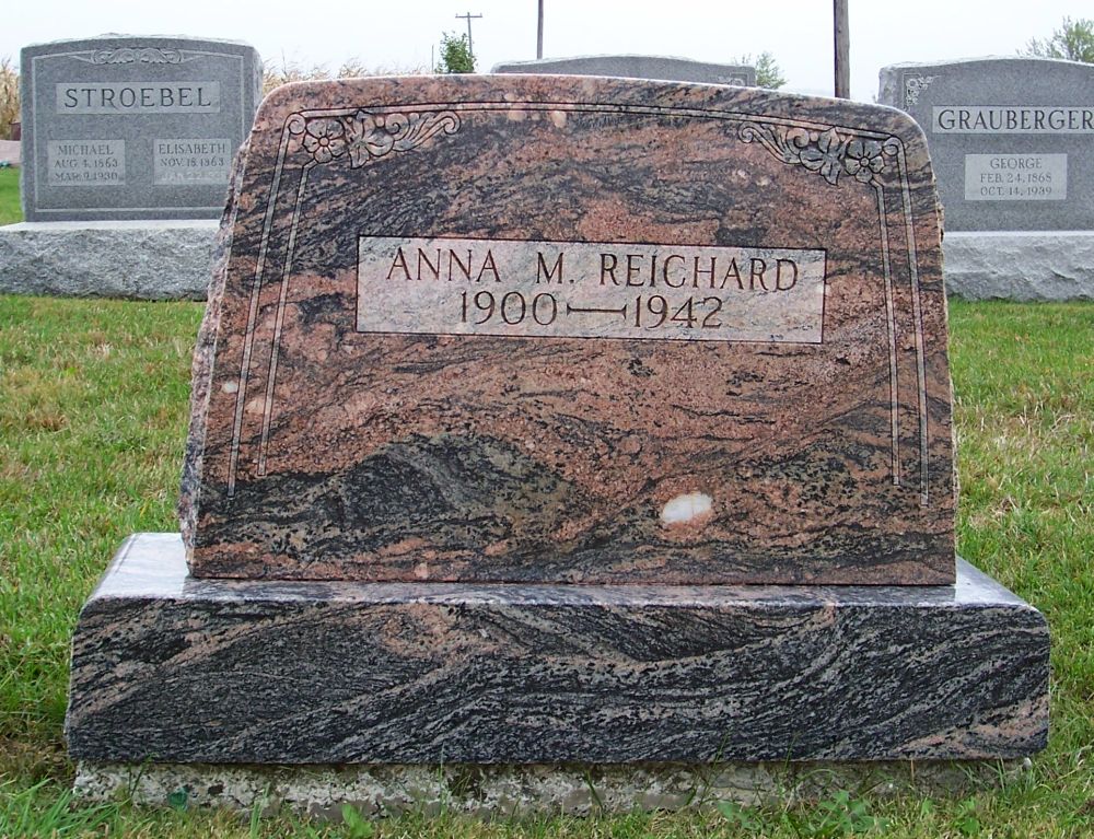
Anna M. (Grauberger) Reichard, Zion Lutheran Cemetery, Chattanooga, Mercer County, Ohio. (2011 photo by Karen)
This is the tombstone of Anna M. (Grauberger) Reichard, located in row 1 of Zion Lutheran Cemetery, Chattanooga, Mercer County, Ohio. The marker is inscribed:
ANNA M. REICHARD
1900-1942
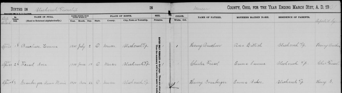
Anna Maria Grauberger was born 27 November 1900, the daughter of Michael Heinrich “Henry” and Emma (Baker) Grauberger. [1] However, her Mercer County birth record indicates she was born 22 November 1900. [2] I tend to go with the church record, which was recorded before the county record.
Anna was baptized at Zion Chatt on 27 January 1901, with Heinrich Becker and Anna Maria Becker as sponsors. She was confirmed 30 May 1915 at Zion by Rev. W.F.H. Heuer.
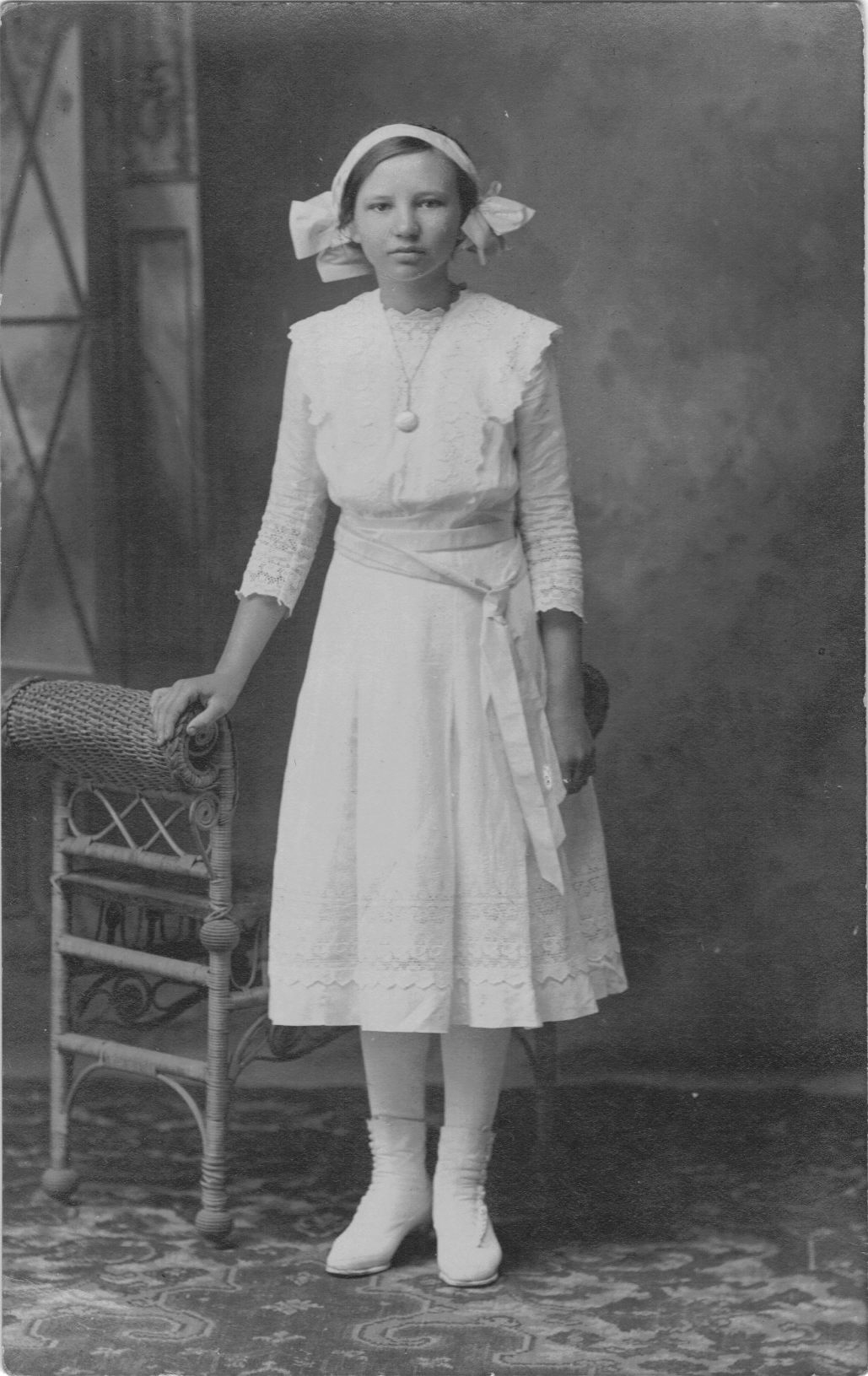
Anna Grauberger confirmation photo, 1915. (photo courtesy of Deb Bollenbacher Reichard)
Anna had three sisters who were named in the church records: Laura Margaretha (b. 1904), Esther Lavina (b. 1911), and Edna Elizabeth, (b. 1913).
Anna Grauberger birth record, Mercer County, Ohio.
Anna Grauberber married John E. Reichard of Willshire on 26 April 1925. The ceremony was performed in the bride’s home by Zion’s pastor, Rev. Jacob E. Albrecht. The church records indicate that John was 19 and Anna was 24.
According to their probate marriage record John was the son of James and Minnie (Sonday) Reichard and was born 26 September 1905. His occupation was a printer. [3]
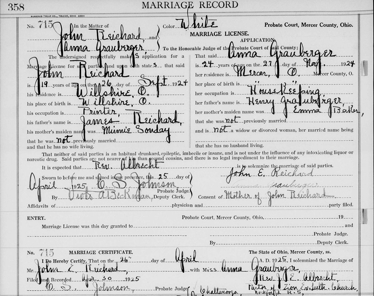
John Reichard-Anna Grauberger marriage record, Mercer County, Ohio, Vol. 12, p. 358.
In 1930 John and Anna lived on State Street in Willshire, where John was still working as a printer and Anna was a housewife. [4] He in fact printed The Willshire Herald, known today as The Photo Star. He was later Willshire’s postmaster. My mom recalls that Anna used to make dresses for her and her sisters when they were little girls.
Anna died 17 May 1942 of septicemia/infection in her blood stream, according to Zion’s records. She was 41 years, 5 months, and 20 days old. She was buried on 20 May and was survived by her husband, son, mother, and three sisters.
Her widowed husband married Dolores E. (Book) Habegger in 1944 and they had a son, Daniel. John died in 1976 and is buried beside Dolores in Willshire Cemetery.
John and Anna Reichard had two children. Their first son, Harold Lee Reichard, was born 7 November 1926 and died the same day of collapsed lungs. According to his death certificate he was buried in the Chattanooga Cemetery, [5] but there is no record of his burial in the church records and no tombstone exists.
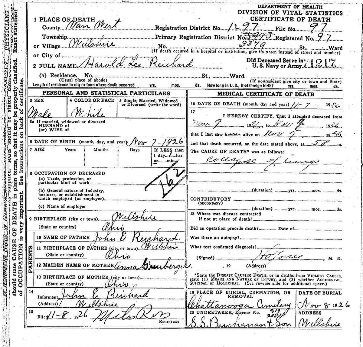
Harold Lee Reichard death certificate.
Their second son, Eugene Vernon Reichard, was born 13 April 1928 and was baptized at Zion Chatt on 14 June 1928. His parents were his baptismal sponsors. Eugene married Betty Weinman in 1948. He died 17 September 2009 and is buried in Willshire Cemetery.
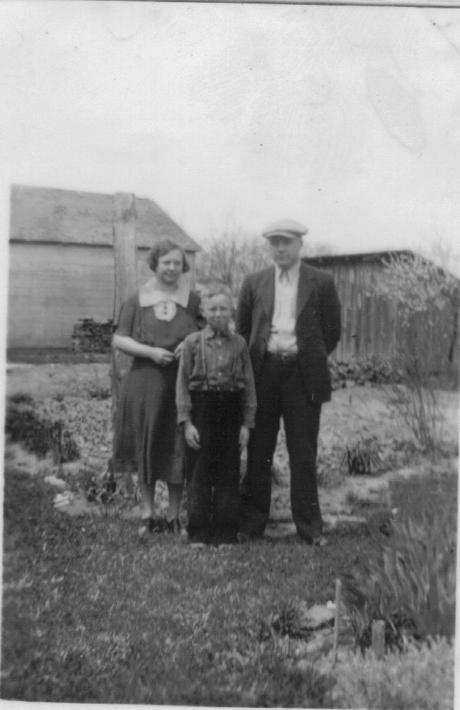
John, Anna (Grauberger) Reichard, and son Eugene. (photo courtesy of Deb Bollenbacher Reichard)
I remember “Gene” Reichard very well because he was our Motorists Mutual Insurance agent for many years, from the time we were married in 1973, until the time he retired.
Anna’s obituary:
Wife and Mother is Beckoned to Eternal Home
There was universal regret and sincere sympathy expressed throughout the Willshire-Chattanooga community Sunday night and Monday morning—regret for the passing of a worthy young wife and mother, sympathy for the bereaved husband and young son—when it became known that Anna Marie Reichard, wife of Postmaster John E. Reichard, of Willshire, had yielded to death’s summons. She died at the Adams County Memorial hospital in Decatur, Indiana at 9:15 p.m., Sunday, May 17.
Ill since March 19, her condition became so unsatisfactory that hospital care and treatment was regarded as imperative, she was taken to the hospital one week ago last Thursday. Failure to react favorably to treatment, a blood test showed an advanced stage of septicemia, and lacking powers of resistance, the inevitable resulted.
Born a daughter of the late Henry Grauberger and Mrs. Emma Grauberger in Blackcreek township, Mercer County, Ohio, she was aged 41 years, five months and 20 days. Always of a religious inclination, she was confirmed as member of the Zion Lutheran church at Chattanooga, May 30, 1915, continuing active in the various phases of the church work until deterred from doing so by ill health.
She was united in marriage with John. E. Reichard, April 26, 1925, since which time she had been a resident of Willshire, and for the past 18 months, was assistant postmaster, which brought her a community-wide acquaintance, which began in 1929, when she assisted Mr. Reichard in the publication of The Willshire Herald, and by all who knew her she was held in the highest of esteem.
Those who survive in their grief are the husband, John E. Reichard, one son, Eugene Reichard, the mother, Mrs. Emma Grauberger, and three sisters, Mrs. John Sipe of near Monroe, Indiana; Mrs. Guy Krall of Rockford, and Mrs. Robert Clase of Chattanooga, Ohio. One son, who died in infancy, preceded her in death.
Mrs. Reichard had been a hospital patient at three different times, undergoing a major operation March 13, 1941, and from that time on the state of her health was all but precarious until the end.
Funeral services from the Grauberger residence, six miles south of Willshire, at 2 o’clock, and from the Zion Lutheran church at 2:30 o’clock Wednesday afternoon, with Rev. Carl Yahl, conduction, the body being laid to rest in the burying-ground of that church. [6]
Thanks to Deb (Bollenbacher) Reichard for providing Anna’s obituary and family photos!
[1] The early church records show the surname name as Becker. Later records spell the name Baker.
[2] “Ohio, County Births, 1841-2003,” index and images, FamilySearch (www.familysearch.org : accessed 13 Jul 2014), Blackcreek Township, Mercer County Births, For the Year Ending March 31st, 1901, unpaginated. Her date of birth was recorded on April? Her baptism was recorded on about 27 January 1901, closer to her birth date. Her age at death also agrees with the date of the church record.
[3] ”Ohio, County Marriages, 1789-1994,” index and images, FamilySearch (www.familysearch.org : accessed 13 Jul 2014), Mercer County Marriage Records 1920-1925, Vol. 12: 358, John Reichard and Anna Grauberger, 26 April 1925.
[4] 1930 U.S. Census, Willshire, Van Wert, Ohio, ED 22, p. 252 dwelling 88, family 88, John Reichard; digital image by subscription, Ancestry.com (www.ancestry.com : accessed 13 July 2014); from FHL microfilm 2341624, from NARA microfilm T626, roll 1890.
[5] “Ohio, Deaths, 1908-1953,” index and images, FamilySearch (www.familysearch.org : accessed 13 July 2014), Harold Lee Reichard death certificate.
[6] Undated newspaper clipping, courtesy of Deb (Bollenbacher) Reichard.