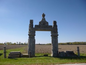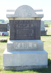
Philip Kable, St. Paul Lutheran Cemetery, Liberty Twp, Mercer Co, Ohio (2023 photo by Karen)
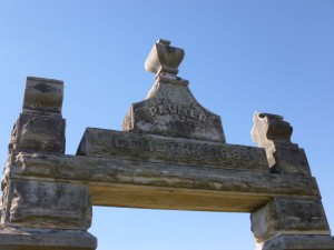
This is the tombstone of Philip W. and Caroline (Koch) Kable, located in row 2 of St. Paul Lutheran Cemetery, Liberty Township, Mercer County, Ohio. The marker is inscribed:
Philip W.
1850-1915
Caroline
1849-1923
KABLE
Christ Is Our Hope
Philip William Kable was born in Liberty Township, Mercer County, Ohio, 9 February 1850, the son of Christian (1814-1885) and Dorothea (Maurer) (1815-1904) Kable. Philip’s parents were both born in Germany, married in Germany, and immigrated to America with their four children in 1846. They settled in Liberty Township, Mercer County, and attended church at St. Paul Lutheran, Liberty Township. [1]
The Christian Kable family in the 1850 census: Christian Kable, 38; “Theresia,” 63 [sic]; Jacob, 10; Christian, 8; Louisa, 8; John, 7; Philip, 7 months. [2] By 1860 the family had another daughter, Katharine, born about 1855. [3]
Philip Kable, age 20, resided with his parents in 1870 [4] and 2 years later, on 15 February 1872, he married Caroline Koch in Mercer County. [5]
Caroline Koch was born in Butler County, Ohio, on 10 September 1849, the daughter of William (1817-1886) and Katharine Elizabeth (Liebrich) (1829-1910) Koch. Her parents were both born in Germany and married in Butler County, Ohio, on 4 January 1849. [6]
In 1850 the William Koch family lived in Milford, Butler County, Ohio: William, 30; Catharine, 20; and Caroline, 8 months. William was a farmer. [7]
By 1860 the William Koch family had moved north to Liberty Township, Mercer County and had a Skeels Crossroad Post Office address. Their family had grown to include 5 children, Caroline, 10; Lydia, John, William, and David. The father William was a farmer. [8]
The William Koch family in 1870: William, 53; Catharine, 42; Caroline, 20; Lydia, 18; John A, 16; David, 10; William, 8; Theodore, 5; Charles, 4; and Philip, 1. [9]
Philip Kable and Caroline Koch married in 1872 and by 1880 they had four children and lived next door to Philip’s parents. The Philip Kable family in 1880: Philip, 30; Caroline, 30; Catherine, 6; Philip [Jr], 5; William, 3; and Louisa, 1. Philip Kable Sr. was a farmer. [10]
Philip Sr’s father Christian Kable died in 1885 and in 1900 Philip’s widowed mother Dorothea Kable, 85, lived with her son Philip [Sr] and his family in Liberty Township. Also in the household were two of Philip Sr. and Caroline’s children, Peter, 18, and Anna, 11. This enumeration indicates that Caroline Kable had given birth to six children, all of them living. [11]
Philip Sr’s mother Dorothea Kable died 23 December 1904 and Philip, Caroline, and their daughter Anna moved to Fort Wayne, Indiana, about 1906.
In 1910 Philip Sr. and Caroline Kable lived at 1312 Packard Avenue [sic?] in Fort Wayne. Philip Sr. worked as a laborer in the Private Families industry. Their daughter Annie, 21, single, also lived with them and worked as a dipper in a candy factory. [12]
In 1913 Philip Sr. and wife Caroline lived at 1312 Park Avenue, and Philip worked as a clerk at GS Clapesattle. [13]
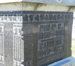
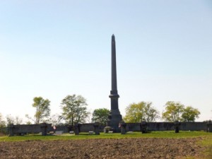
Philip W & Caroline (Koch) Kable, St. Paul Lutheran Cemetery, Liberty Twp, Mercer Co, OH (2023 photo by Karen)
Philip W. Kable Sr. died at his home in Fort Wayne on 6 March 1915, at the age of 65, from chronic laryngeal and pulmonary tuberculosis. Philip’s occupation was a clerk in a drug store. [14]
Philip Kable Sr. obituaries:
Kable-Philip Kable, aged sixty-five years and for the past nine years a resident of this city, died late Saturday night at his home 1325 [sic ?] Park Avenue, flowing a six weeks’ illness. He was employed at the Clapesattle drug store on South Broadway. The widow and the following children survive: Mrs. J. Weinman, Philip, William and Peter Kable, Mrs. William Hunsicker [sic] and Mrs. Gimke [sic]. The funeral will be held Monday afternoon at the residence and Tuesday the body will be shipped to the former home of the deceased in Mercer County, Ohio. [15]
Philip Kable, a well-known former resident of Liberty township, died at his home in Ft. Wayne last Saturday night, the 6th, at the age of 65 years. He was born in Liberty township and was taken there for burial, where services were held at the St. Paul’s Evangelical church on the 9th. He was married to Caroline Koch, who with three sons and three daughters survive him. [16]
I am not sure exactly where the Kable family lived in Fort Wayne. Three sources give three different addresses.
After Philip Sr’s death, widow Caroline Kable moved back to Liberty Township, Mercer County, and lived with her widowed daughter Louisa Hunziker and her two children. [17]
Caroline (Koch) Kable died in Van Wert on 1 June 1923. [18]
Philip W. Sr. and Caroline (Koch) Kable had the following children:
Catherine Kable (1873-1957), married Jacob Weinmann
Philip W. Kable Jr. (1874-1947), married Louisa Alt; married Gertrude Maurer
William Kable (1876-1963), married Elizabeth K. Anselman; married Anna Marie (Steinhardt) Burmeister
Louise Kable (1878-1977), married William Christian Hunziker
Peter Kable (1881-1968), married Augusta Wilhelmina Steffen
Anna W. Kable (1888-1972), married Victor H. Dimke
[1] Familienbuch, St. Paul Lutheran Church, Liberty Township, Mercer County, Ohio, Christian Kable family, p. 24.
[2] 1850 U.S. Census, Ohio, Mercer, Liberty, p.287A, dwelling 19, family 20, Christian Kablea [sic]; Ancestry.com.
[3] 1860 U.S. Census, Ohio, Mercer, Liberty, p.356, dwelling 971, family 976, Christ Kable; Ancestry.com.
[4] 1870 U.S. Census, Ohio, Mercer, Liberty, p.146A, dwelling 62 family 57, Christine [sic] Kable; Ancestry.com.
[5] Ohio, U.S., County Marriage Records, 1774-1993, Mercer County, 1861-1887, p.303, Philip Kable & Caroline Cook [sic], 15 Feb 1872; Ancestry.com.
[6] Ohio, U.S., County Marriage Records, 1774-1993, Butler County Marriages 1803-1879, p.56, William Koch & Catharine Librick [sic], 4 Jan 1849; Ancestry.com.
[7] 1850 U.S. Census, Ohio, Butler, Milford, p.190A, dwelling 1037, family 1048, Wm Cook [sic]; Ancestry.com.
[8] 1860 U.S. Census, Ohio, Mercer, Liberty, p.358, dwelling 992, family 997, William Cook [sic]; Ancestry.com.
[9] 1870 U.S. Census, Ohio, Mercer, Liberty, p. 145B, dwelling 58, family 52, William Cork [sic]; Ancestry.com.
[10] 1880 U.S. Census, Ohio, Mercer, Liberty, ED 188, p.16 [penned], dwelling 135, family 142, Phillip Kable; Ancestry.com.
[11] 1900 U.S. Census, Ohio, Mercer, Liberty, ED 85, p.12, dwelling 230, family 236, Philip Kable; Ancestry.com.
[12] 1910 U.S. Census, Indiana, Allen, Fort Wayne Ward 6, ED 48, p.11B, dwelling 252, family 259, Philip Kable; Ancestry.com.
[13] U.S. City Directories, 1822-1995, Fort Wayne, Indiana, City Directory, 1913, Philip Kable; Ancestry.com.
[14] Indiana, U.S., Death Certificates, 1899-2011, Philip Kable, 6 Mar 1915; Ancestry.com.
[15] Fort Wayne Daily News, Fort Wayne, Indiana, 8 Mar 1915, Philip Kable obituary; Newspapers.com.
[16] The Celina Democrat, Celina, Ohio, 12 Mar 1915, Philip Kable obituary; Newspapers.com.
[17] 1920 U.S. Census, Ohio, Mercer, Liberty, ED 140, p. 15B, dwelling 316, family 337, Louisa Hunziker; Ancestry.com.
[18] Ohio Deaths, 1908-1932, 1938-1944, 1958-2007, Caroline Kable, 1 Jun 1923; Ancestry.com.