If you enjoy seeing how county boundaries changed over the years, you will want to take a look at The Newberry Library’s online Atlas of Historical County Boundaries. Their website provides an excellent timeline with an explanation of the boundary changes.
I will use my home county, Mercer County, Ohio, as an example of how to use this interesting feature.
To go directly to the page: Atlas of Historical County Boundaries.

Newberry Library Atlas of Historical County Boundaries
Click on “Go to Maps” and select Ohio.
Newberry Library Atlas of Historical County Boundaries
The screen below shows the area that included what is now Ohio in 1778, named Illinois County. You can advance the timeline two ways. One, by using the drop-down timeline on the right side of the page, which includes a description of the map. You can also advance the timeline at the bottom of the page, using the sliding timeline, advancing a year or two at a time.
The old county boundaries are superimposed over a current map and you can zoom in and get a closer look of the area.
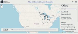
Newberry Library Atlas of Historical County Boundaries, 1778, Illinois County.
Newberry Library Atlas of Historical County Boundaries, 1778, Illinois County.
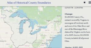
There is a brief history with each map. On the first map image, Ohio Map 12/9/1778-2/29/1784 : Change: Illinois County (Va., extinct) created by Virginia to encompass all territory north and west of the Ohio River and east of the Mississippi River claimed by Virginia on the basis of its 1609 charter; Illinois County included all of present Ohio.
By 1800, the southern portion of Mercer County was Hamilton County and the northern portion was Wayne County. Sort of. The dividing line was at an angle.
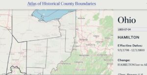
1800, Hamilton County, Newberry Library Atlas of Historical County Boundaries.
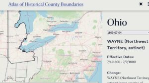
1800, Wayne County, Newberry Library Atlas of Historical County Boundaries.
By 1803 we see a change. Our area was called Montgomery County.
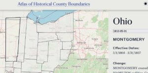
1803, Montgomery County, Newberry Library Atlas of Historical County Boundaries.
By 1812 what we now know as Mercer County was called Non-County Area 6, part of Montgomery lying north of the Indian Boundary reverted to Non-County Area 6, attached to Darke, indirectly through Darke to Miami for administrative and judicial purposes.
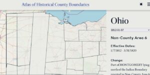
1812, Non-county area, Newberry Library Atlas of Historical County Boundaries.
There was a big change April 1820, when Mercer County became a county. It was created from Non-County Area 6 attached to Darke and Non-County Area 7 attached to Shelby. There was no Auglaize County at that time and St. Marys was the county seat of Mercer County. Allen County was directly east of Mercer County.
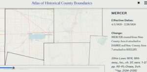
1820, Mercer County, Newberry Library Atlas of Historical County Boundaries.
The next big change was in March 1848, when Auglaize County was formed. Mercer exchanged with Darke and lost land in the creation of Auglaize, and lost land to Allen and Van Wert.
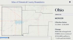
1848, Mercer County, Newberry Library Atlas of Historical County Boundaries.
The Mercer County boundary timeline ends at 1888.
In addition to the map images, the drop-down timeline on the right has additional features. The first selection is “All Changes.” That page gives the Consolidated Chronology of State and County Boundaries, telling all the state and boundary changes for the selected area. Also in that drop-down is a “Commentary” about Ohio. Both are good resources if you are looking for narratives, not maps.
This gives you an idea of what you can learn from these maps of county boundary changes, for any county in the country.
Very interesting, with a lot of history and very easy to use. Have fun looking through these maps.